|
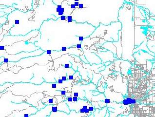
 Maps
of Mines & Mills in Boulder County Maps
of Mines & Mills in Boulder County
These maps were developed by the Boulder County Health Department
as part of a study on radon gas. (See Background
below). Many thanks to Susan Martino and Diana Shannon for helping make
these available to the public through BASIN.
 Mining
has played a major role in the development of the Boulder area-- from
the coal mining in the Coal Creek and Rock Creek drainage's to the hard
rock mines and mills along Middle Boulder Creek and Left Hand and James
Creeks. These mines and their milling operations still have an impact
on our lives today. Heavy metals from these mines and mills have the
potential to leak into surface and ground water, making them a health
concern in some areas, and soil radon gas due to mining/milling activities
is a concern on or near some sites. Mining
has played a major role in the development of the Boulder area-- from
the coal mining in the Coal Creek and Rock Creek drainage's to the hard
rock mines and mills along Middle Boulder Creek and Left Hand and James
Creeks. These mines and their milling operations still have an impact
on our lives today. Heavy metals from these mines and mills have the
potential to leak into surface and ground water, making them a health
concern in some areas, and soil radon gas due to mining/milling activities
is a concern on or near some sites.
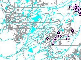
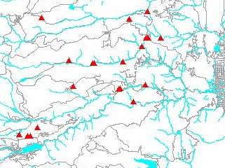
Select on the map to link to a large (180K) version of the entire County.
Also see Map Notes.
 |
Coal Mines
Coal was king in eastern communities such as Marshall, Louisville,
Lafayette and Erie until the middle of the 20th Century where
over 80 coal mines once operated. Historically coal mines were much better mapped than
hard rock mines. Coal mines were usually located near urban centers
for economic reasons, they required a larger work force to extract the
coal and were generally owned by big business. Smoldering fires (some begun
in the 1870s), subsidance of land and mine drainage are among
the impacts that the extensive coal mining has left on southeastern
Boulder county.
|
 |
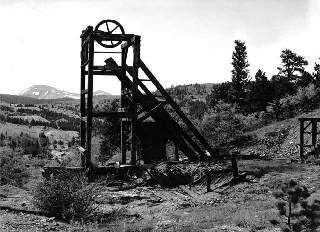
Hard Rock Mines
Placer gold deposits found along Gold Run Creek near Gold Hill
in 1860 were the start of a hard rock mining legacy that moved
from gold and silver into tungsten around the turn of the Century. Hard rock mines were
often the enterprise of one or two people in a remote area. It didn't
take much gold for it to be valuable and it was fairly easy to transport
from remote sites. One could probably conjecture that it was to the
hard rock miner's advantage not to extensively map his finds.
By 1920 most mine operations were shut down due to shifts in the
global metals market, but some small-scale mining operations continue
today in the Boulder area.
|
 |
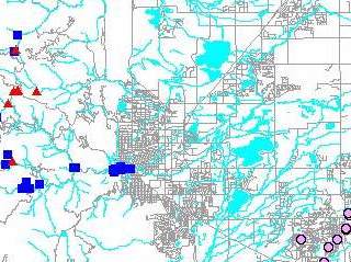
Mills
Near the mouth of Boulder Canyon and into downtown Boulder many
mills have processed ore from mines in the surrounding mountains.
Other mills were located closer to the mines. These mills sites
in some cases still contain concentrations of toxic materials
such as heavy metals, and in some cases radioactive materials
from the milling of radium.
|
 |
Combined Mines & Mills
While very little mining and milling now takes place in the Boulder
area, these activities have played an important and colorful part
of our local history and development. Historic mining and milling sites' environmental
hazards/impacts such as heavy metal accumulation, subsidence, mine dumps,
acid drainage, radon, etc. are among the present day concerns
that are left from this era. There can also be physical hazards such as open mine shafts, adits, abandoned
equipment and buildings. The mines and mills mapped here represent only
those sites that were surveyed as part of the radon study.
|
For additional information, see the various resources listed in the Mine
& Mills Bibliography.
|
|
Background
The Rocky Mountain Region has been ranked as a Zone
1 area for radon by the Environmental Protection Agency. A Zone 1 area
has the highest radon occurrence possible. Radon is also listed as a
Group A carcinogen and is definitely known to cause cancer in human
beings. Colorado's high levels of radon are believed to stem from the
geology and possibly from the ways in which the dirt, debris, and waste
from decades of mining and milling have been disposed.
Boulder County Health Department/Environmental Health
has received four grants to date from the Colorado Department of Public
Health and Environment to inventory and to sample late 19th and early
20th century hard rock mill/mine sites and coal mines in Boulder County.
Sampling consists of testing for soil radon gas and radium. Historical
research has revealed at least 300 hard rock mill sites, at least 500
hard rock mines sites and at least 80 coal mine sites alone in Boulder
County. The goal of this ongoing project is to gather soil radon and
radium data on mountain/foothill/plains sites which may have increased
potential for radium and radon gas due to past milling/mining activities.
Increased radon potential can lead to higher levels of radon gas in
new or existing structures on or near these sites. The principal means
of radon entry into a home is through openings in walls and floors in
contact with the soil.
|